A Belmont County parcel lookup gives users direct access to property information using a unique parcel number. This tool is vital for property owners, real estate agents, and public users who need accurate land details, ownership records, and tax information. By using a parcel search in Belmont County, users can quickly verify property boundaries, assess land value, and check zoning classifications, all within a centralized system. The land parcel database includes official records that support informed decisions for buying, selling, or managing property. Accurate parcel data also helps avoid disputes and ensures clarity on ownership, taxes, and legal property status.
The Belmont County parcel system organizes property information in a simple, searchable format, making it easy to locate details without confusion. Users can access records such as current ownership, land size, structures, and tax history in one place. Property professionals rely on this tool to confirm listings, while homeowners use it to track improvements or plan developments. Public users may reference the system for research on neighborhood trends or land usage. By providing consistent and verified property data, the parcel lookup improves transparency, supports planning, and strengthens confidence in property decisions.
What is a Parcel Number and How It Works
A parcel number is a unique identifier assigned to each piece of property in Belmont County. It acts like a digital fingerprint, helping local authorities track property ownership, taxes, and land records efficiently.
Parcel ID / Property Identification Number
A parcel ID, also called a property identification number, is a code used by county offices to organize land and property records. This number is unique to each property, ensuring there is no confusion between parcels with similar addresses. In Belmont County, parcel IDs are often structured with a combination of numbers that indicate the township, range, section, and lot. For example, a parcel ID might look like 12-34-056-000, where each part gives specific information about the property’s location on county maps.
Parcel IDs serve several important purposes:
- Property tax tracking: Counties use the parcel ID to calculate and record taxes for each property.
- Ownership verification: It confirms who legally owns a piece of land.
- Land records organization: Each parcel ID links to deeds, surveys, and zoning information in the county database.
Property professionals and buyers rely on parcel IDs when completing real estate transactions. They provide a more precise reference than street addresses, which can sometimes be duplicated or change over time. Using the parcel ID ensures that all legal documents and records match the exact property in question.
Differences Between Parcel Number and Property Address
A parcel number and a property address serve different purposes in property records. While the parcel number is a numeric or alphanumeric code that identifies the property in official county systems, the property address is the location description used for mail delivery and general reference. The property address may change over time, for example, due to street renaming or new subdivisions. In contrast, the parcel number remains consistent, making it a reliable reference for property parcel lookup and tracking legal documents. The county parcel map uses parcel numbers to visually display boundaries, zoning, and ownership details in the land parcel database.
Distinctions include:
- Stability: Parcel numbers remain the same even if the property address changes.
- Official use: Parcel numbers are used in tax records, deeds, and legal filings.
- Mapping precision: Parcel numbers link directly to maps showing exact property lines, while addresses are more general.
When performing a real estate parcel search, users can access the county parcel map to view property dimensions, neighboring parcels, and historical records. This makes it easier to identify potential issues with boundaries, easements, or zoning restrictions.
Methods to Search for Belmont County Parcels
Searching for property records in Belmont County is simple once the right tools are used. Users can look up parcels by owner name, address, or parcel number using the official county portal and GIS system for precise property details.
Search by Owner Name
A parcel search in Belmont County by owner name helps identify all parcels connected to a specific individual or business. This method suits people researching property ownership lookup or verifying who owns a home or land. The official county search tool lets users enter a name and see associated parcels and key details.
How to search:
- Go to the Belmont County Real Estate Search: https://belmontcountyauditor.org/Search/Name
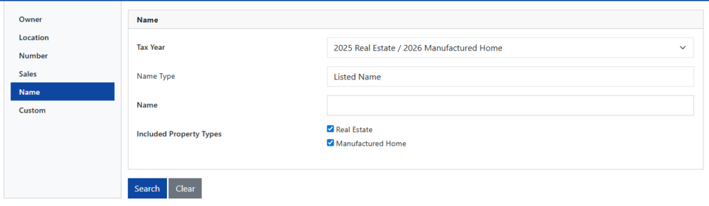
- Choose the “Owner” or “Name” option on the search page.
- Type the last name first, then the first name if known.
- Pick the tax year if the option appears to narrow results.
- Review results showing each parcel tied to the owner, including parcel number, location, and assessed value.
Search by Address
A Belmont County parcel lookup by address gives quick identification of an exact property when the street location is already known. This method works well for homeowners, buyers, or real estate professionals who want a real estate parcel search with straightforward results.
Steps address search:
- Open the Belmont County Real Estate Search tool at: https://belmontcountyauditor.org/Search/Location (Official Address search)
- Choose “Location” or “Address” from the search fields.
- Enter street number and street name accurately.
- Add city and zip if the system asks for additional filters.
- Click Search to view details, such as parcel number, owner name, and assessed value.
Points to remember:
- Fill in as many address details as possible (street, city) for narrower results.
- Misspellings or missing suffixes like “Rd”, “St”, or “Ave” often return unrelated parcels or none at all.
- If many results show up, sort by city or zip code to find your target property quickly.
Search by Parcel Number / Parcel ID
Using a parcel number (also called Parcel ID or PIN) gives the most direct result in a property parcel lookup. This method eliminates guesswork and ensures a specific parcel is retrieved immediately. Parcel IDs are unique, so entering the correct number brings up one exact record.
Workflow example:
- Visit the main search portal: https://belmontcountyauditor.org/Search (Unified search handles parcel ID entries)
- Pick the “Parcel Number/ID” field in the search form.
- Type the number exactly as it appears on tax bills or legal documents.
- Press Search to view that parcel’s full record, including owner, property class, tax history, and GIS map links.
Why this method is powerful:
- A correctly formatted parcel number returns a single record, removing confusion.
- It’s useful when processing multiple records in bulk or in legal transactions.
- Parcel results often include links to GIS mapping and tax history.
Accessing Historical and Ownership Records via Parcel Lookup
Belmont County property parcel records provide detailed insights into past and present ownership. Users can access historical data and ownership history quickly through the county’s online tools and public databases. These records are valuable for verifying property ownership, researching land history, or conducting due diligence before a purchase. They include information such as previous owners, transfer dates, property descriptions, and legal boundaries. By using a property ownership lookup, anyone can track changes in ownership and gain a clear picture of a parcel’s history over time.
Viewing Ownership History
Ownership history allows users to see who has held title to a property in Belmont County over the years. This information can be crucial for resolving disputes, confirming inheritance lines, or understanding property trends in specific areas. Most historical ownership records are stored in the Belmont County Auditor’s Office or accessible online through the Belmont County Parcel Viewer. Users can search using a property address, parcel number, or owner’s name.
The results typically include:
- Current Owner: Name of the property holder and contact information.
- Past Owners: Full list of previous owners, including purchase and sale dates.
- Property Type: Residential, commercial, agricultural, or undeveloped land.
- Parcel Details: Acreage, lot dimensions, and property improvements.
For more detailed research, the historical parcel database can show ownership going back several decades. Many records include deed references, allowing users to view legal documentation of transfers. These records are especially helpful for attorneys, real estate investors, or anyone performing a property ownership lookup.
Property Transfer Records
Property transfer records detail changes in ownership and legal transactions for a parcel. They are essential for anyone conducting a parcel search in Belmont County or performing a property parcel lookup for verification purposes.
Transfers can include:
- Sales Transactions: Records of property sold, including sale price and date.
- Gifts or Inheritances: Transfers resulting from estate settlements or family gifts.
- Foreclosures or Liens: Instances where ownership changed due to financial obligations.
The Belmont County Recorder’s Office maintains official transfer documents, while the Auditor’s online portal provides a convenient summary view. Users can search by:
- Parcel Number
- Owner Name
- Property Address
These records allow users to track ownership changes over time, verify legal ownership, and confirm property details before purchases or investments. Transfer history also supports tax assessment research, zoning compliance checks, and market analysis for local real estate trends.
(FAQs) About Belmont County Parcel Lookup
Belmont County parcel lookup allows users to find property details quickly using a parcel number or address. The system provides information about ownership, parcel size, tax data, and legal descriptions, making it easier to verify property information and use the land parcel database effectively.
How do I find a parcel number in Belmont County?
A parcel number or parcel ID is a unique code for each property. Users can find it on the Belmont County Auditor Parcel Search page by entering the owner’s name, street address, or legal description. The results will display the parcel ID along with property details. This number is essential for performing further property parcel lookup and accessing tax or ownership records.
What information does a parcel ID provide?
A parcel ID gives details like owner name, lot size, property type, tax assessment, and legal description. It also links to past deeds and recorded transactions in the land parcel database. This identifier helps property owners, buyers, and researchers verify ownership and review property features efficiently.
Can I search parcels by address?
Yes, the Belmont County system allows searching by address when the parcel number is unknown. Enter the full street address, including city and zip code, to get accurate results. The system shows the parcel number, property details, and a GIS map view of boundaries, making parcel search in Belmont County simple and quick.
How do I check ownership history?
Ownership history is available through the property parcel lookup tool. Users can enter the parcel ID to view previous owners, recorded deeds, and transaction dates. This helps confirm legal ownership, review property transfers, and track changes in land records over time.
Is the GIS parcel map free to access?
Yes, Belmont County’s GIS parcel map is free to use. It shows property boundaries, zoning, easements, and topography. Users can overlay parcel layers, check land features, and confirm details visually. Combined with the land parcel database, it helps residents, investors, and professionals get accurate property information without any cost.